Great Lakes Depth Chart / Contour Map


Print Profile(1)

Description
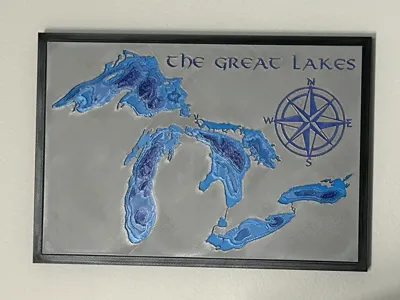
Here is a stylized Great Lakes depth chart. The focus here is on the Great Lakes themselves, not on the land or rivers surrounding them. The only rivers to appear on the map are those that connect the lakes. It also should be noted that for artistic reasons, the lakes depths are not all drawn at the same scale. Lake superior is the deepest lake on this map, followed by Michigan/Huron, Ontario, and Erie, as they should be. However, Lake superior is much deeper than the other lakes, and Lake Erie is very shallow in comparison to the other lakes, so in order to create visual interest in Lake Erie (as well as Lake Ontario) different scales were used for each lake.
To create the color gradient for the depths you will need to have two blue colors, I used blue and cyan. The land is made from white, red, and yellow, so the model does use 5 colors and you will need to make a swap during the print. Colors are assigned by layer height, so if you wish to scale this up for a larger print bed, be careful not to scale the z axis or you will need to reassign the color changes. The frame is on a separate plate and is only black so that the model has a nice clean look when assembled.
This is a model that I designed and present freely to everyone, please do not sell copies of it.
Boost Me (for free)
Comment & Rating (6)