


Print Profile(1)
Description
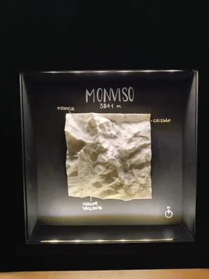
Topographic model of Monviso, 3,841 m, the highest mountain in the Cottian Alps and source of the Po River (Italy's longest and most important river)
Model derived from aerial scans by Italian and French topographic institutes
The model's resolution is 5m
The overall elevation has been exaggerated compared to reality to more convincingly represent its prominence
Lightning infill and 15% density to consume less material and achieve a sufficiently rigid structure
Boost Me (for free)
License
You may create derivative works based on this object, provided that all such derivative works are published exclusively on the MakerWorld platform and include proper attribution to the original creator. You may not share, upload, host, distribute, or publish this object—or any derivative work of this object—on any other digital platform, marketplace, or distribution channel. Commercial use of this object and any derivative works is strictly prohibited. This includes, but is not limited to, selling, renting, sublicensing, or using the object in any context in which you receive monetary compensation or other financial benefits.
Comment & Rating (0)