3D topographic map of the Lake Biwa area during the Sengoku period


Print Profile(1)
Description
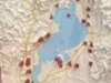
This is a 3D topographic map of the Lake Biwa area during the Sengoku period. Although it has been reclaimed now, the shape of Lake Biwa has been altered to visually demonstrate how the lake extended all the way to Azuchi Castle.
・Vertical magnification: 7x
・North-South: 73.58km, East-West: 73.78km
・Northern limit: Tsuruga, Southern limit: Koka, Eastern limit: Sekigahara, Western limit: Kyoto
The map symbol for the old battlefield of Sekigahara is missing, so a revised version is planned for future release.
#Create_GBM
License
You shall not share, sub-license, sell, rent, host, transfer, or distribute in any way the digital or 3D printed versions of this object, nor any other derivative work of this object in its digital or physical format (including - but not limited to - remixes of this object, and hosting on other digital platforms). The objects may not be used without permission in any way whatsoever in which you charge money, or collect fees.
Comment & Rating (0)