Search models, users, collections, and posts


Print Profile(1)

0.12mm layer, 2 walls, 40% infill
Designer
3.6 h
1 plate
Open in Bambu Studio
Boost
10
32
1
1
19
10
Released
Description
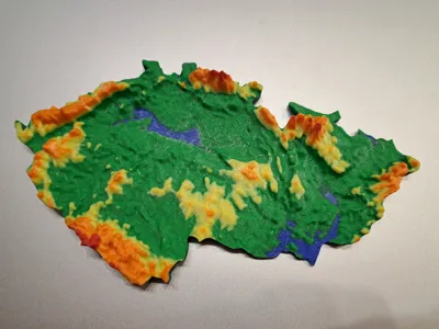
Elevation map of the Czech Republic
Original model was modified - split into two parts vertically, platform was made thinner, upper part - the terrain - was exaggerated in z-axis to accentuate the mountains and hills.
- Elevation exaggerated - 150 m AMSL to 1620 AMSL corresponds to 2.3 to 19.5 mm of the model.
- Color scale is not linear, it is adjusted to highlight higher hills and mountains.
- Pause at each new color layer to manually change the filament, no AMS expected.
- 0.12 mm layer thickness, the tinner layer thickness, the better the blend between colors.
- Prime tower removed, smoother color blend is desirable.

Comment & Rating (1)